Drainage in the RM of Wallace-Woodworth was, once again, before Reeve and Council at the regular meeting of August 11.
See below for more photos
Since 1996, ratepayer Vince Heaman, a farmer with property five miles north of Virden, has been trying to get something done about the growing volume of water on his property in the spring, or after a rain.
Senior Water Resources Officer Darren Nicklin, and Barb Kingdon, Water Resources Officer for this area, were also at the meeting.
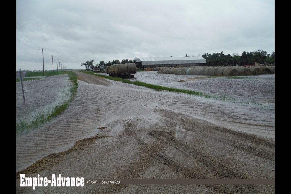
Heaman provided photos of fields and cattle yards. The first five pictures were high water; the sixth was a result of the water, including loss of a calf at calving time, saying, “You can’t get to them.”
He provided maps in an attempt to show the natural and historic stream flows.
Applications for drainage changes must be made through the Water Resources Officers, who met with Vince Heaman last fall.
Reeve Denis Carter noted this is not just a problem that occurred last week, with heavy rain.
“In 1996,” Heaman said, “Something’s happened here.”
The farmer (on land his family purchased in 1948), points to one place where water is over the road, saying, “That’s what is bothering me the most.”
Heaman says the water has been manipulated by drainage and dams which have altered the natural run of water. A creek that used to carry water eastward to the Assiniboine Valley, about five miles distant, is often dry.
“For example, in 1976 that railway track washed out,” he says, indicating just how high the water was. But at that time, his road (which regularly floods) did not flood, “There was zero water went over our road at that time.”
Pointing to the map he said, “That’s the natural creek...it’s not being utilized now because that creek runs dry now.”
Heaman says that culverts installed by a previous council “used to balance the sloughs. They have now become rivers.”
An RM road was constructed years ago, which Heaman thinks is part of the problem. Water flows over that road, a phenomenon he first pointed out in 1996. The flow, he says, has increased over the years.
Even with two culverts recently licensed for his property, he points out that he should not have a creek flowing through his yard, where there wasn’t one before. “The water going through my yard is not a creek, it never has been...so therefore we’re dealing with this water that’s coming in, that shouldn’t be coming in.”
Problem for RM and Virden
The farmer continued, “I feel this is as much of an RM problem as it is a Vince Heaman problem. The reason is, if water stays in its natural creek, crosses the railway, goes a mile east, there’s no end structure, no yard sites involved...” He says the change in water flow means that it flows through his yard now to several neighbours places which cause them problems, and on to the RM [yard].
Heaman says the water flows into the creek that flows through Virden. “If you look back in history, you’ve done a lot of repairs. You don’t need the extra expense.”
Reeve Denis Carter thanked Heaman for his presentation saying Heaman’s concerns about illegal drainage should be investigated. I’m asking you,” he turned to Water Stewardship, “what we need to attend to as an RM...?”
Nicklin, the senior water officer said, “We’ll look into some of it. I’m not sure if we can look at it all. As for the RM, “It’s up to you, what you want to do. We step in once the application is in.”
Carter pressed for some professional direction and said, “We’re asking you...If we say we want to put in some 10-foot culverts, what are you going to say?”
Niklin conceded that he did not know the lay of the land as well as the local people do.
He pointed out that changing a 15-inch culvert to a 36-inch culvert would add water to downstream people. “You’ve got to talk to the people along the way. But that’s all up to you. We need everybody’s downstream approval...”
Barb Kingdon appeared skeptical of some of Heaman’s analysis, and rejected elevations taken from Google Earth, noting these can be wrong by as much as 30 feet.
Councillor Sandy Heaman spoke up. “The area has been problematic...the water runs all the way from the west. [We] have been engaged numerous times by affected ratepayers in that area.
“You are right,” she addressed the ratepayer. “There is water coming south.” She spoke of a plan that had been discussed previously and said, “Sadly, we’re now getting pushback on that. My concern is, even though you ...have a really good idea what to do with [the water], I’m not sure that we’re going to be able to get the downstream cooperation.”
The farmer interjected that just today he had to pull a baby calf out of a mud hole to safety.
Councillor Heaman stated, “I’m not disputing that, it’s just, if we cannot get people in a very broad area to agree to a plan, then we’re stalemated.”
The councillor said they were dealing with a whole block of ratepayers all the way from Hwy 83. The ratepayer interjected that some farmers farm with a backhoe, (referring to draining fields).”
The councillor stated, “When you have works going on behind the scenes, while you’re trying to come up with a plan, it complicates the issue.”
Vince Heaman addressed the chair and stated emphatically, “If you go three miles north (to Two Creeks on the municipal map) there used to be a 12-foot cement bridge there. It was replaced with a 6-ft culvert. That 12-foot bridge would run full.... Now that six-foot culvert doesn’t run full. Where did that water go? I’m saying that water’s coming south...The water that’s coming to Virden is coming all the way from Two Creeks and its passing Two Creeks where it should go to the Valley, and its coming all the way to Virden.”
Turning to the government representatives, Kingdon and Nicklin, Reeve Carter said, “Could you investigate that?”
“We need definitive proof,” Nicklin replied. “If there’s a backhoe out there, phone Barb, phone me.”
But Nicklin also referred to professional elevation surveys, and Carter said, “Don’t you think this is a case where you should get them out?”
The senior officer agreed to look into that.
Kingdon frustrated
Sounding perplexed, the licensing officer went on, “I have worked hard for three to four years trying to find answers... I’m about up to here, with trying to find solutions for landowners.”
Kingdon had complied with Heaman’s request for culverts, but one was ineffective, with no ditch to help that water continue moving on. “There’s an oil lease in the middle of it now, so it’s a bit of a mess. And I’ve looked at adding culverts closer to the elevator at Harmsworth, but I don’t know where the actual drain is there. It’s along the railway. We need more information.”
Carter, in an effort to conclude the meeting asked, “What is required of us? Let us know.”
Kingdon said she has Heaman’s application on file but she needs more information.
Carter asked Water Stewardship to pursue that information and to take another look at the past manipulation of drainage.
With resignation he said the RM might have to talk to landowners all the way to the Assiniboine River, where it all ends up, pointing out that it’s not far away.
Kingdon said, “No...When I ask for a sign off, it is until it (the water) gets into a system that normally runs water...we’re not going to go miles and miles.”
Heaman stated, “Well I’m looking for a conclusion. I’ve been dealing with this for years and years. I want to know what’s going to happen and when. And I want it sooner rather than later.”
Carter asked for her conclusions and recommendations by the end of this year, pointing out, the RM needs to plan. “This won’t be free for us, when we’re talking about buying culverts.”
Kingdon committed to giving a report on what she looked into; what she found, both for drainage paths for this water and the drainage manipulation that Heaman referred to.
“If I can prove that there’s works there, that have occurred in the last 20 years, and I have to start shutting them down,” she pointed out, it would impact the RM.
UARCD
Nicklin, the senior officer, suggested another approach to the water dilemma. “I believe you’re part of a Conservation District. Have you engaged them to look into a surface water strategy for this area?”
He explained that the CDs have a lot of tools and they could help to set up a strategy for drainage and water management.
With that, the 45 minute discussion ended and the meeting went ‘in camera’.


