Oh, how Mother Nature can torture us. Give us a glimpse of an early spring, then just take it back and push us back into the depths of winter. March was nice, at least it seemed like it was, right compared to this arctic start to February, I mean April.
In fact, March was not very friendly to us, we were on average 0-2°C below our climate normals for March. Take Brandon for example, Brandon had an average temperature over March of -7.2°C. That is a full degree colder than what is usually expected for March, -6.2°C. Historically in March Brandon averages around 15 days with above zero temperatures and 15 days with below zero temperatures. March 2018 was a different story, Brandon had 10 days above zero, 2 at zero, and 19 days below zero. It wasn’t like we were just barely below zero either, Brandon woke up to fifteen mornings where the air temperature was below -15°C.
However, Westman got a huge break compared to our fellow Prairie dwellers out West. The majority of southern Saskatchewan and southern Alberta were on average 3-5°C colder than their historical averages. Areas around Brooks Alberta saw over a 5°C decrease in their monthly temperature. This puts a massive hold on the start of the Agricultural year. Areas in Southern Alberta are usually waiting on the calendar to start seeding rather than the weather. This year it appears that it will be the cold that is holding back there start to the year.
In Manitoba, it is usually the weather that our farmers are waiting on to start seeding. As soon as that soil temperature and overnight lows are warm enough we push in the seed. With temperatures staying this cold and with a snowpack that is still kicking around there will be an inevitable delay to the start of seeding, one could assume close to two weeks behind schedule.
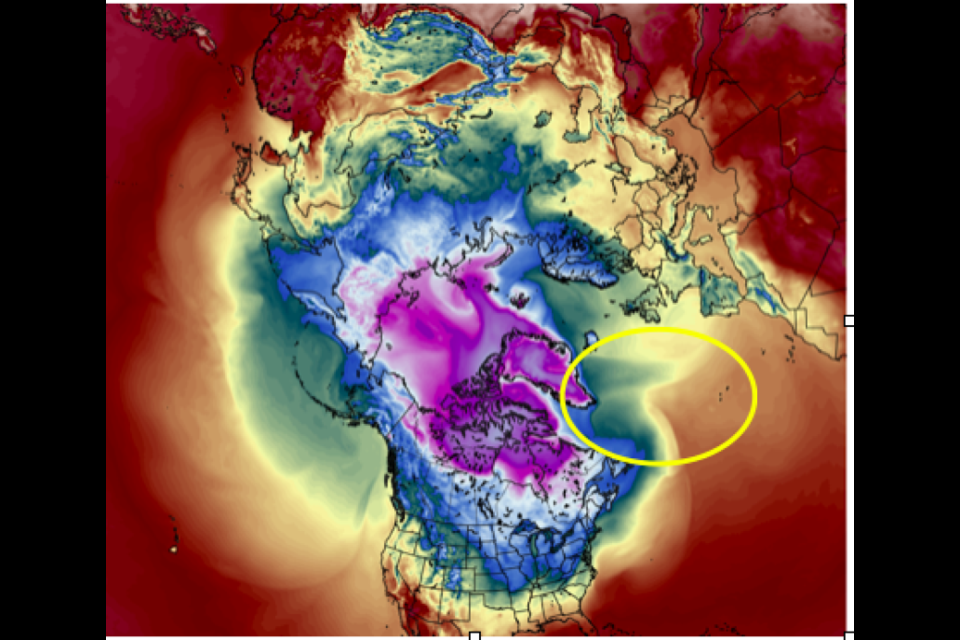
Our cold temperatures are the result of a stubborn, stationary mass of warm air over North Atlantic that has blocked the normal flow of air from west to east and south to north. This warm air mass has altered the flow of the Jet Stream creating a strong northwesterly flow aloft. Thus, bringing a pile of cold air down from the Arctic. The ridge of warm air can be seen in Figure 1, west of Newfoundland. The warm colours of tan and brown are protruding north towards Greenland. As long as this stays in place we will continue to experience below normal temperatures.
So, when will this change? That is a very good question. In order for us to get back into a normal flow something need to knock this warm air in the North Atlantic out of the way. It appears that a couple strong low-pressure systems move through the North Atlantic later this week and early next week. They should be strong enough to knock this warm air lose and change the pattern over North America.
Figure 2 shows the upper-level wind pattern over the Prairies for April 10, 2018. Notice that the flow is completely from the Northwest. Northwest flows come from the Arctic and bring cold air into the prairies.
This will change, as the wind pattern changes by the end of April. The pattern has shifted to a wavier pattern, which helps inject warm air from the south into the prairies.
Westman should start seeing normal temperatures again the last week of April, about two weeks behind schedule. The Eastern Prairies will be the first to return to normal, the Western Prairies will continue to be below normal into early May.
So hope this was a little bit of good news, there is a light at the end of the tunnel.


